By Keith Gibson
Buchanantown was a small community that existed across the Guyandotte River from Lyburn, WV. Actually, it was about halfway between Lyburn and Neibert, across from the old Route 10 which is now known as “Hanging Rock Road.” I’m not really sure when the community was first called “Buchanantown” (probably between 1885 and 1890) but I do know that according to the 1841 Logan County (West) Virginia Land Grants, Alexander Buchanan purchased 30 acres of land, at 10 dollars per acre, on the Guyandotte River in Logan County. At first I thought it was referring to the property that later became “Buchanantown,” but the property he bought in 1841 was at the mouth of “Spice Creek.”
Alexander, born in 1797, left Tazewell Virginia and arrived in Logan with his wife Nancy (Crabtree, born 1795) with four sons and two daughters. Henry, born 1819; Thomas, born 1821; Hannah, born 1824; James, born 1826; Susannah, born 1828; and John Michael, born 1833. According to the “General Index to Deeds, Logan County, WV”, The property at “Spice Creek” in 1841 was just the beginning. The records show that during the next 55 years (1841 to 1896) the Buchanans of Logan County WV owned, or had owned, property at “Beech Creek”, “Aracoma”, Several tracts of land on the Guyandotte river, Several tracts of land at “Gilbert Creek”, The “Left Fork of Spice Creek”, “Neds Branch”, “Laurel Branch”, “Big Branch” on the Guyan river, and “Elk Creek”, just to name a few. And what is now known as “Dairy Hollow” at Neibert, according to the U.S. Geological Survey map of 1928 was called “Laurel Branch.”.
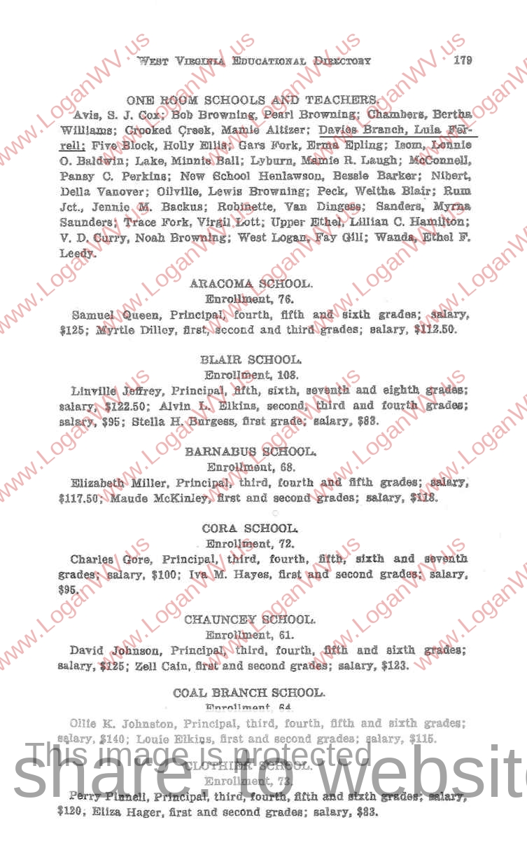
One day back in the early 1960s, when I was in my early teens, mom pointed out the remains of a foundation of a one-room elementary school she attended during the early 1920s that taught first through the eighth grades which was located in Buchanantown at the mouth of Davy Branch. Just before she passed away in 2005, she gave me some old pictures that had belonged to my grandma, and also gave me the old elementary school diploma she received when she graduated from the eighth grade. I noticed that it looked like someone had erased her first name on the diploma and asked her about it. She told me that she was named after her grandmother, “Eliza”and didn’t particularly like the name because the kids she went to school with teased her and would sing “Little Liza Jane”, and she was the one who erased it.
There is no trace of the old school left, and you can’t even find it on any of the USGS historical (early 1900s’ s) Topography maps. However, I contacted the Cultural Center in Charleston, WV and the Director of Archives and History said that the 1921-22 Directory lists a one-room school at the mouth of Davy Branch. My brother and sister, who were born in the early 1930s, remember being allowed to attend the school even though they were too young to even start school. They also said that the teacher allowed them to sit in class with our aunt Blanche, and lived in the boarding house that our grandma ran. It was also said that the school was burned down by two of the local boys because they didn’t want to go to school.
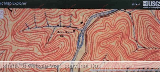
According to the USGS Topography maps of Logan County, there were 8 houses in Buchanantown in 1926 and 5 houses in 1911. The 1891 USGS Topography map for Logan shows only three houses in Buchanantown, and it appears that the one at the mouth of Davy Branch was the Floyd Buchanan homeplace.
Anthony Lawson Jr.owned the Land at Davy Branch until 1869 and according to Logan, WV land records, sold it to Eli Gore Sr. for $500. Sixteen years later in 1885, Floyd Buchanan purchased 2 tracts of land containing 30 acres (for $480 plus taxes and fees) at Davy Branch on the Guyandotte River from the same Eli Gore Sr..
Another thing I noticed was that the 1869 deed mentioned: “the land situated at or near the mouth of Davy Branch embraced a part of ‘Cloyd’s Island.’ I believe “Cloyd’s Island” was at the upper end of Buchanantown, and was an actual island back in the 1800’s. When I was growing up back in the 1950s and 60’s, everyone at Buchanantown referred to it as “The Island.” The only time it actually became an island (back when I was a kid) was during the spring flooding season when the Guyandotte River would rise and overflow the bank on the west side, thus creating an island. This was before the Justice Dam was constructed in 1980. After 1980 the “occasional” island ceased to exist.
The 1891 USGS Topography map of Logan County plainly shows an island just upriver from Davy Branch. It’s also visible on the 1896 map. However, it doesn’t appear on the 1911 map or the 1926 map.
This is so interesting ,My father was born in Nitro W.V I found property that was in Kapp’s name and I claimed it and Dad went there and found Kappridge Rd.
Street sign.He did not no about any of this if I didn’t tell him there is more but would rather keep it until I have papers in my hand
Thanks for sharing,There used to be a big farm Kapp Farms I think
Amazing !
Hi Jack! Yeah it is amazing to find out this info about the place where we grew up. I’ve really got hooked on digging up information about our ancestors. I was really amazed to find out that a couple of your papaw’s (Hayden) ancestors were Knights under King Robert I and King Robert II of Scotland back in the 1300’s. – Uncle Keith