By Connie Baisden Marsh
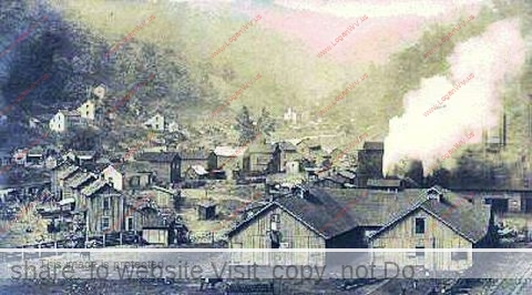 Our coal mining community on Mud Fork in the county of Logan deep in the hollows of West Virginia had at least two slate dumps. Slate is a gray rock that splits into thin layers, and is separated from bituminous coal that is left piled up high as waste. One of the slate dumps near our coal camp was on fire and the other wasn’t.
The first slate dump was behind the coal mine tipple in a valley called Nineteen Hollow. A row of houses was directly beneath this black, smoking monster. Thousands of feet high and blocking a valley with refuse from the mine, the mountain of waste was on fire and large crevices split the surface with flames licking out of slits. The dump emitted an odor of sulfur and burned for years. The smell was always there, but people were so used to it that it just became part of the surroundings.
Behind the dump stood a pool of water with black silt on top. Some of the older boys would go up and swim in the water in the summertime, but they were warned not to do so.
During the spring and autumn rains, residents became worried of the amount of water that was building up behind the slate dump and groups of people walked up the road by the dump to reassure themselves and their families there was no danger.
My family and I lived in the second coal camp beneath the huge creature, directly in its path. I had many nightmares about the slate dump splitting open and the water washing us away just like another one did on Buffalo Creek about seventeen miles away that killed over a hundred people in 1972.
Sometimes on a Sunday when the mine was not working, Mother would allow us to walk up the road by the slate dump. The area was so quiet; no animals could be seen and the birds even stayed away. Dead trees with their leafless twisted limbs stood as in protest of their destruction.
Looking down into the cracks to see the hot embers smoldering within the earth, I could see the wind blowing the smoke and smell down the hollow. Mother would threaten us with, “If you aren’t good, when you die, you are going to a place like that,” which frightened us. The slate dump was reclaimed in the 1970s and no longer exists.
The other slate dump was up another hollow and it wasn’t on fire. We amused ourselves on this one. It was on the side of the mountain and a group of older kids introduced us to sliding down the slate on anything that we could find. Fortunately for us, a garbage dump was only a few yards away.
The most thrilling thing to be found to slide on was the hood of a car. Several older boys and girls would pull the hood up the mountainside and then slide down screaming and yelling while everyone jumped out of the way.
The smaller kids would find cardboard boxes to haul up the hill and then slide down. It took a while getting back up the mountain of slate. I remember it being so hot that sweat ran down my face, but the headlong exhilarating ride was worth it all.
This went on for most of the summer. Mother kept wondering why we were coming home in the evening covered from head to foot in coal dust but no one would tell. Well, someone let it slip and those joyous and energetic rides down the slate dump ended pretty fast. I believe I might have told my baby sister about the fun. She cried to go and when we wouldn’t let her, she told Mother. One mother told the next until everyone knew. The rides down the slate dump stopped abruptly.
We were scolded severely and heard how we could have been killed sliding down the slate dump. We slipped back a few times and slid without anyone knowing, but we were then too afraid that something bad would happen. So those hot summer days of sliding down the slate dump ended.
*Used with the permission of the author.
We had a Slate Dump at Slabtown in Logan…We played on it all the time…There was an End-of-Track next to it, where an old Switch Engine was parked…We called it the Dinky…My Mother grew up in the same area and told me about when it was operational, moving Train Cars around…
The #20 Whitman Mine also had a huge slate dump with large water pool behind it. My Mom forbid my brothers to ever partake in the swimming in that pool as was rumored to be taking place In the late 1950’s by the teenage boys in the area. My brother, Larry Hardesty, always had to have the last word with Mom and loved telling her that she wouldn’t know if he did swim in that pool; however, he was proven wrong on a certain day when she accused him of having done so, with him adamantly denying any such thing. She then revealed to him that although he had stayed away long enough for his hair to dry, he failed to pay attention to his tee shirt, which was wrong side out. He then got a good switching, not for the swimming but for lying about it.
I remember that big pool of water on the old slate dump. I also live in Larry’s/Zida’s old house. Grew up 2 doors down from there too. Lived up #20 all my life.
Several drownings occurred at the Holden site and I came very close to death there myself one summer.
I used to live in mud fork back in the 60s till my mom died 1970 we all moved on after that …
I am looking for information and photos of Rock House Road. Anything would be appreciated.
Lots of info online.
Earling Grade School was built on a “slate dump”! Our school yard was on fire! Can you imagine kids playing near that? They filled in the sides with the refuse from the coal mine. So you could see and smell it burning. How did they get away with that kind of stuff?
Our house in Rita Camp had a “slate dump” behind it. The river on the other side of it. So when it flooded in the 1960’s it came around it, and we had to leave very quickly in the night.
I wonder about the health of all of us that lived around that toxic smell all day and night. I know several people had/have cancer. Sad that the coal companies got away with treating people like that.
I was the one that told my mom about everyone sliding down the slate dump. And they wouldn’t let me. Connie is my older sister. I remember the sulphur smell, the trash, glass and heat of the sun. I remember stepping on the crunchy, crushed glass and black rock.
Kathy, glad you all are still alive with no health issues.
Some people called the slate bug dust.for black coal.
Just wondering if your family is related to the
Curtis Baisden family?
Hopefully those playing in this Toxic Waste
didn’t have health issues during their lives.
Curious where is 19 Hollow located ?
I, like everyone else in coal towns, grew up referring to the places where mine refuse material was dumped (and usually burned from spontaneous combustion) as a “slate dump”. As I understand it, this is a substantial “geological” mistake. Generally speaking, “slate” rock is not prevalent in West Virginia coal fields. The “mine refuse” material placed into the dumps is a “shale” rock intermixed with coal (which catches fire). Perhaps it is better to refer to these dumps as “refuse piles”.
Google maps show 19 Hollow Road on Mud Fork on the left going up the road about a mile above Verdunville Post Office. Island Creek’s Mine #19 was on the right side of this hollow which is where the #28 Mine tipple’s refuse pile was. At one time there were a dozen or so coal camp houses in the hollow that were displaced by the refuse pile there. The hollow is called Lefthand Branch, Lefthand Fork and Argonne Branch on various maps. (Argonne is the name of the subdivision of the coal camp just below #28 tipple and the houses in the hollow were also called Argonne subdivision.)
As ominous as it looked and smelled, the refuse pile in 19 Hollow was probably no higher than about 200 feet and was about 2,000 long. I have heard it said that in the latter years of its operation, the material put into it had so much coal in it that the material had a heat value (BTU per pound) of some 8,000 BTU per pound when marketable coal had some 12,500 BTU per pound. Accordingly, the pile burned like in a furnace.
There were basically two types of these refuse piles, one being the “valley fill” type that filled in across hollows like at #28; the other type being a “side hill dump” type where refuse was dumped along the side of a hill or dumped into bottoms. Both types tended to catch fire and burn and, most did. In addition to # 28 there was a valley fill type in the large hollow on the right just above Verdunville which I think people referred to as the trash dump area. ( I understand the rubble and scrap from the Hinchman home burning was hauled there.)
There was also a small valley fill type in the first right-hand fork of Ellis Hollow behind the Ellis Cemetery. There was a lot of areas where mine refuse was placed in bottom lands and along creek banks. I seem to recall the bottom above the gas plant at Workman Branch was filled with refuse. The area at the upper end of Calloway Camp across the creek about where Corridor G bridge crosses was a dump. The bottom land going up Ellis Hollow was a dump too. A lot of the older mines had “tram road” haulage tracks on the hillside at the level of the coal seam where coal was hauled and they also hauled mine refuse and dumped it over the hillside.
I think that Milkhouse Hollow on lower Mud Fork near Mt. Gay had a substantial amount of refuse dumped in it, presumably by Gay Coal & Coke. I seem to recall that part of Midelburg Island was filled in with mine refuse material by Gay.
It is interesting to note that in early days when people talked about the “island” at Logan, there wasn’t an island in the river, they were referring to an island at the mouth of Main Island Creek where the creek forked forming an island before it entered the river.
I appreciate all the info you have posted. Does your resource show the coal camps Rita and Wilbur/Wilburn? We have been trying to figure out more about the mines that were there. (Rita had a different name at one point. It was called Spankum and we don’t know why. LOL
Arlene,
I have a copy of a map titled: “EARLING & LYBURN MINES- WEST VIRGINIA COAL-COKE CO.”. I don’t know if the mines were operations of WV Coal & Coke or the map is just a map they prepared for whatever reason.
The map shows general outlines (with some details) of mines in the vicinity of Lyburn, Rita, Earling and Taplin.
There are 3 general areas of mining shown. One area is MANBAR COAL COMPANY which appears to have been opened in a small hollow just below the large Pine Branch hollow at Earling. This was a large mine.
Another area is titled: TAPLIN MINE- STANDARD ISLAND CREEK COAL CO. That large mine appears to have been opened on the right hand fork of Henry Hollow near the mouth of it at Taplin. There also were a couple of MERRILL COAL COMPANY MINES, Nos. 2 and 3 up Henry Hollow in that same area.
The map shows a large mine opening up in a small hollow at the “upper end” of the Rita Mall area. Today, at that small hollow there is an exit off the new road that goes to some water tanks up on the hillside. You can see signs of some old caved in mine workings at that exit about 25 feet up on the highwall. It is unclear on the map but that mine “appears” to be connected to, or part of, a large mine opened at Lyburn. Indications are that AVIS EAGLE COAL COMPANY had a large mine at Lyburn.
Note that there was relatively small mine called EPIC MINE at the lower end of the Rita mall area. This mine appears to have been limited in size by encountering a fault area.
1913 USGS topography maps indicate that none of these mines were there in 1913 (although the railroad was there). The only community in that area shown on the 1913 maps was Manbar.
1926 USGS maps show that there were mines at Lyburn, Wilbur, Earling (Manbar P.O.) and Taplin. The 1926 maps indicate that substantial coal camps had been built at each location by then. Likewise, the community of Neibert had been built by then although I don’t know if it was a “coal camp”.
I note that the large hollow at Neibert was called Laurel Branch on 1913 and 1926 USGS. The 1963 maps called it Camp Branch and a hollow across the river at Neibert began to be called Laurel Branch. Camp Branch was also known as Dairy Hollow and a coal mine was opened up in that hollow in later years.
I can add my two cents’ worth on Epic, which was about where the Rita shopping center is now. My father, W. T. Harvey, and two other investors started up the mine in the late 1940’s or early 1950’s. The name came from the three seams of coal on the property — Eagle, Powellton and Island Creek. As I remember from what Dad told me later, they just weren’t able to sell the coal, probably because of market conditions. All of the principals lost everything they’d put into it.
Robert,
Thanks for the explanation of the Eagle, Powellton, Island Creek coal seams in the naming of the EPIC Mine and your father’s association with it.
I would add some information which you will appreciate. Namely, the “Eagle” seam you mention is in reality the Campbell’s Creek (aka No. 2 Gas) seam. The true Eagle seam underlies the Campbell’s Creek seam by 100 feet or more and the true Eagle seam is below drainage from about Peach Creek to a very short distance below Man.
There are several mines in Logan County “incorrectly” named as being in the Eagle seam. This “error” was carried forth from the earliest days of mining. The error originated in early geological surveys of Logan County and in the 1915 WV Geological Survey of Logan-Mingo counties corrected the error but most coal companies continued to use the Eagle name for many years.
For instance, Island Creek’s Mine # 28 opened on Mud Fork in the late 1940’s is listed on their maps as in the Eagle seam but was actually in the Campbell’s Creek (No. 2 Gas). However, in core drilling activities I worked on in 1967 while working for Island Creek, they called the Mine #28 seam the No. 2 Gas seam. Likewise, early maps show the Melville, Dabney, Dehue. MacBeth mines as Eagle seam mines but later maps show those mines in the No. 2 Gas seam.
Thanks for your commentary!
Arlene,
In my earlier comments I mentioned that none of the early (hand-loading) mines in the vicinity of Rita were there in 1913 based upon the 1913 USGS maps. However, in further research I found that MANBAR COAL COMPANY was operating then and the population of Manbar in 1912 was listed at about 700. This suggests that much mining was ongoing in the Rita-Earling-Taplin area in 1912. (The town of Holden itself was estimated to be about 600 at that same time, some 8 years after Island Creek had begun substantial production).
Indications are that at those early times, LOGAN MINING CO. had some 10 bee-hive coke ovens at their EARLING MINE.
The previously mentioned EPIC MINE apparently was a later mine (1940’s era) opened in the fringe areas of an earlier (1913?) hand-loading era mine called WILBURN MINE operated by RICH CREEK COAL CO.
The earlier mentioned mines installed in Camp Branch (Dairy Hollow) were the MAPEL ENERGY INC. #1 and #2 mines. They were 1980’s era mines. Those mines were acquired by NEIBERT COAL CO., INC. and may have been operated by ZOLA MINING, INC. in the late 1980’s. CAMP BRANCH COAL CO., INC. had permits approved for 2 mines in Camp branch in 1982 but I don’t know if they were ever mined.
In the late 1980’s, the H&B COAL CO. had its #1 and #2 mines in Henry Hollow at Taplin in the fringe area between the early MERRILL COAL COMPANY mines # 2 and #3 up Henry Hollow in that same area.
Of course there was the Elkay #1 mine at Earling. This mine may have been a 1950’s era mine. There was a permit approved for a Elkay #2 Mine in Henry Hollow at Taplin in the mid 1970’s but it was never opened.
does anyone know what ” Red Dog ” is?? I’m from Lee County Virginia. ” Red Dog” as we called it ,is the result of slat dump burning.
Charles, online search shows name from the high heat when the Shale was burned.
The slate dump below the mine at Holden 22 was a favorite place to visit by groups of boys that lived in 22 holler (Hollow). At the main dump, built up by a contiunous dumping by a tram was a favorite place called the “big hole”. This hole was full of water and so deep that no one ever attempted to touch bottom. The water was really clean and had a greenish blue tint that lost clearness after about 6 feet. At the “big hole” we would build dive platforms and swings out of trees that game great excitement to all the boys whl ventured there. That is my most vivid memory of a slate dump.
Denny Linville
Walton Hills, OH
As a child growing up on Crooked Creek I recall a refuse dump on the left side going up the holler. It too was on fire with the same great smells and all that goes with it. I left Logan County in June 1959 taking a lot of wonderful memories with me. I have returned to Logan a few times since then, on one of the trips I went up Crooked Creek again and noticed the refuse dump had been cleaned up. In its place was a beautiful new home that I admired very much, much better than anything I ever lived in when I was there. Clint “Butch” Ward, Haysville, KS.