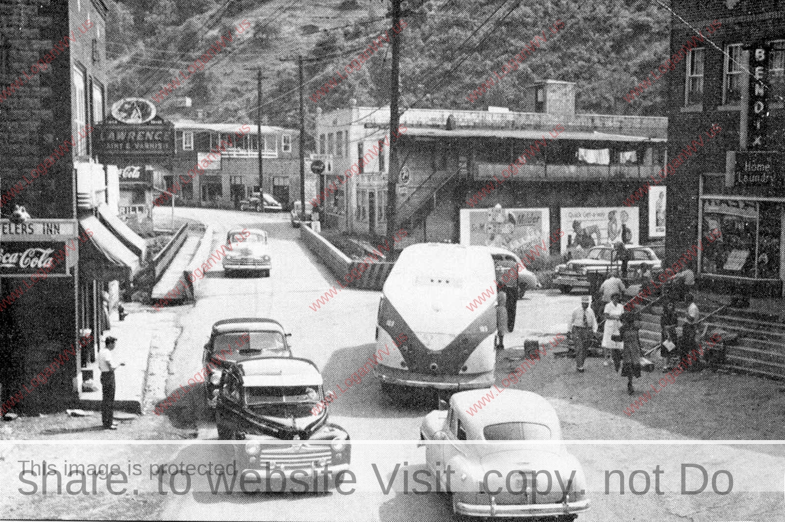
About 1948 at Monitor Junction looking toward Fisher Bottom and Cherry Tree. The Esposito Bldg. is shown on the right. Used with permission courtesy of wvhistoryonview.org.
Mount Gay was originally called Gay, West Virginia which derived its named from Harry S. Gay. Jr. owner of the Gay Coal & Coke Company. The Gay Coal & Coke Company opened the first mine in Logan County in 1904.
1916 Ad
Throughout the 1950s, everyone living at Mount Gay, Whites Addition, Cherry Tree, Fisher Bottom and Shamrock received their mail at the Mount Gay Post Office. Fisher Bottom was located adjacent to the lower end of Cherry Tree. In 1957, Fisher Bottom and the old Cherry Tree Grade School were demolished to make room for the Logan Blvd.
Cherry Tree, June 1988 courtesy of Bob Piros
Everyone is welcome to share our images on Facebook, etc., but please use the Share Button. Share don’t take.
Mount Gay Area Photo Gallery
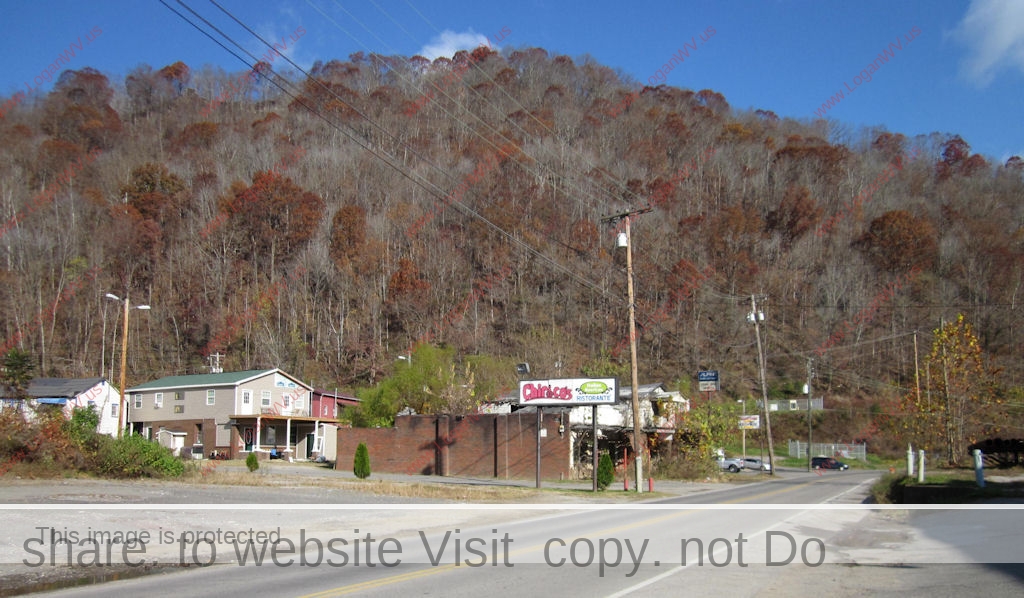
Photo taken 11-14-11.
Black Bottom
Black Bottom
Black Bottom from City View
Black Bottom
The old Kroger Lot at Black Bottom
Photo taken 11-14-11.
The old Fortuna's Produce Market taken 11-11-11. Image 11253.
Black Bottom
Black Bottom
Photo taken 11-14-11.
Photo taken 11-14-11.
Black Bottom
Mount Gay near Black Bottom. Image 4685.
The old Busy Bee Beer Garden at Mt. Gay taken 11-11-11. Image 4685.
Fortuna's Market and next door, the previous Busy Bee Restaurant at Mt. Gay. Courtesy of Dwight Williamson. Image ref. 14231.
1924 Cherry Tree near Logan, WV courtesy of Brandon Ray Kirk
“This photo is of myself, Lurinda Stonoff, on the left, with my father Robert (Bob) Stonoff. It was taken in about 2007 at his mother’s (my grandmother’s) gravesite in the Mt. Gay area. She was buried behind the home she had lived in for decades. (She actually lived in two different houses on the same site. The first one, which had no indoor plumbing, burned and another more modern one was built. A yet newer house had replaced it by the time this photo was taken. Dad was born and grew up in the area. His mother’s name was Nola Baisden. Dad died on 12-9-2019, a month short of his 90th birthday.” Image 7146.
1952 Centennial Program Booklet, Page 100. When this photo was taken, it wasn't just called Back Bottom and Mt. Gay. Each section was named. (1) Deskins Addition, (2) Ellis Addition (1 and 2) aka Black Bottom, (3) Billy Goat Junction, (4) Mt. Gay, (5) Monitor Junction, (6) Fisher Bottom, (7) Cherry Tree Bottom. Image 1697.
Looking toward Mt. Gay showing the Gay mine in the distance. The date on the photo isn't clear enough to accurately read but it looks like 1922. Courtesy of Jack Browning. 314122
1915 photo of the Gay Coal Mine. The mine shipped the first carload of coal Thanksgiving day, 1904. Courtesy of Jack Browning. Image 281584.
John Mills Signs building at Mt. Gay courtesy of Donetta Adams Pack. The building was located on the road to Holden about a quarter mile from the Cherry Tree Bridge directly under the bridge that now connects 73, 44 & 119. 487911
1909 Cherry Tree and Gay Mine. Logan Banner photo from the 1952 Centennial Program Booket published by the City of Logan.
About 1948 Monitor Junction at Mt. Gary looking toward Fisher Bottom and Cherry Tree. The Esposito Bldg. is shown on the right. The man on the left is Woodrow Thompson. He lived at Whites Addition. DeHaven´s store and DeHaven´s Transfer & Storage is across the bridge on the right. Used with permission courtesy of wvhistoryonview.org. 115681
William (Billy) Erlewine leaving for the Army, October 17th, 1966 from the Logan Bus Terminal. Growing up, Billy lived at Whites Addition and Cherry Tree.
Gay Mine history. Photo from the 1952 Centennial Program Booklet published by the city of Logan, WV. 31467
Old Gay Coal Company Store, credit The Black Diamond.
The old Mt Gay, WV Coal Co. mine portal where Jack Dempsey worked before becoming world boxing champion! Courtesy of Michael Taylor.
Courtesy of Helen Bigler Star. She writes. My grandfather was Guiseppe Scaramuzzino known to everyone in Mt. Gay as S Joe. This is a picture of Mt Gay looking toward Logan taken in the late 40s or early 50s from the top of my Grandfather´s building.
Mt. Gay courtesy of Helen Bigler Starr. She writes. This is my grandfather, Joseph (Giuseppe) Scaramuzzino, known to most everyone as S. Joe. This is also my sisters and me! I’m not sure what year this is, but I’m guessing 1948 because my baby sister was born in November 1947. This in Mt Gay where he had a large grocery store, a garden and chickens. An alley is there now that bears his name. 8942
Shamrock Beer Joint courtesy of Dwight Williamson.
Mt. Gay Freewill Baptist Chruch courtesy of Brenda Whtieclould Duty-Mitchell.
2014 Atkins Safe and Alarm, Cherry Tree, WV. Courtesy of Bob Piros.
2014 Cherry Tree back alley courtesy of Bob Piros.
2014, Monitor Junction, Mount Gay courtesy of Bob Piros.
2014, Monitor Junction, Mount Gay courtesy of Bob Piros.
2014, Motel Across from the old Mt. Gay Grade School courtesy of Bob Piros
2014, Mount Gay courtesy of Bob Piros.
2014 Old Mt. Gay Grade School courtesy of Bob Piros.
Located at Mt. Gay. Photo courtesy of Michael Taylor.
1963 Shamrock. Photo from the collection of Beulah Whitt Cremeans courtesy of her sister, Donetta Adams Pack.
Beulah Whitt Cremeans, 1954, Davis Drive-In, Mt. Gay, WV. It was located where Kroger is now. Photo courtesy of Beulah Whitt Cremeans.
Monitor Junction RR Bridge 11-11-2011.
Mount Gay 11-11-2011
Tracks looking toward Mount Gay 11-11-2011.
1963 flooding at Mount Gay showing the Esposito Building courtesy of Bob Piros.
1963 Flood at Cherry Tree courtesy of Bob Piros.
Postcard showing the flooding of the Mt. Gay area postmarked Logan May 30, 1908. Message on the back: “Here is a view of Gay Town one mile from Logan. See how the flood completely surrounded it. Sure was one of the worst floods for years in this county. We were shut off from every place for 15 days. With love to all, write soon. Raymond”. Image 78915.
1920s Mount Gay, W Va. looking toward Cherry Tree. Photo from the collection of Julia and Walter Shelton, courtesy Ralph Mcneely and the Museum in the Park.
Unidentified lady and Posey Brogan. If you can identify the lady, please leave a comment. Photo courtesy of Mike Baisden.
Photo courtesy of Mike Baisden. On the left is Mae Brogan. If anyone can identify any of the others, please leave a comment.
Flooding at Holden Road
1940 flooding at Monitor Junction at Mt. Gay courtesy of Bob Piros.
Vito Esposito Building at Mt. Gay.
1963 Holden Rd at Mt. Gay flooding courtesy of Bob Piros.
1938 flooding at Monitor Junction at Mt. Gay with Fisher Bottom in the background. Courtesy of Bob Piros.
Samson home and service station 1988 courtesy of Bob Piros.
Nagy's Grocery and residence taken 3-24-2014 which are scheduled to be torn down.
Old home of Steve and Anna Tarkany taken 3-24-2014.
Pilgrim Holiness Church (now Assembly of God) and the previous home of John & Anna Bush. Taken 3-24-2014.
Logan County, WV Island Creek RR Bridge and Gay Mine postcard dated April 2, 1907.
A 1939 LHS Yearbook photo showing area flooding. The Mt. Gay Coal Mine is in the background.
Back of the old Nagy Grocery at Cherry Tree taken November, 11, 2011.
What´s left of the Fortuna´s Produce Market - November 11, 2011. It has been demolished.
Gay Coal and Coke Co., Mt. Gay, West Virginia Courtesy of Sam Tiller, Logan Hydraulics, Cherry Tree, WV
Vito Esposito Bldg. at the Monitor Junction section of Mt. Gay November 11, 2011
Cherry Tree taken November 11, 2011.
Cherry Tree taken November 11, 2011.
Cherry Tree taken November 11, 2011.
Cherry Tree bridge built in 1917. Photo taken November 11, 2011.
Old John Bush Service Station at Cherry Tree. Photo taken November 11, 2011.
Cherry Tree taken November 11, 2011.
Old Nagy Grocery at Cherry Tree taken November, 11, 2011.
Remains of the old Mt. Gay Coal Mine taken 11-11-11.
Inside of a store located in Mt. Gay that was run by Albert Dingess, Jr. and his wife, Mollie Agnes Gore Dingess. Courtesy of Norm Nelson via Bobbie Henthorn Spiers.
Cherry Tree - 1950s John Bush Station and Nov. 2011 Ronnie & Bobby Szakal with Jack Tiller
Currently in the Mount Gay gallery on this website, Photo #2 is the same photo recently posted (January 11, 2020) on the Logan County, WV History and Memories Facebook site (and various other Facebook sites) where it was described as being: “….. the old Mt. Gay, WV Coal Company mine portal where Jack Dempsey worked before becoming world boxing champion….”. The elevation of the pavement at the concrete structure shown in the photo is 662 feet (https://www.mapwv.gov/flood/map/). The “bench” just above the road and concrete structure is where the coal company railroad siding was. The railroad bench is at about 680 feet elevation.
The concrete structure seen in the photo IS NOT a mine portal that Jack Dempsey used when he worked at a Gay Coal and Coke mine. IF the concrete shown in the photo is a portal of a Gay Coal and Coke mine, it is a mine that was opened when Jack Dempsey was 35 years old, long past being world champ.
As can be seen in Photo #21 in the Mount Gay gallery, the original Gay Coal and Coke mine opened in 1904 was in the Cedar Grove (aka Island Creek) seam located about 200 feet higher up on the hill than the railroad. That coal seam was about 6 feet thick and at an elevation of about 860 feet. Records indicate that in 1915, this was the only mine Gay Coal and Coke had in operation. Boxer Jack Dempsey was 20 years old in 1915 and if he ever worked at a Gay Coal and Coke mine, it would have been at the Cedar Grove seam mine high up on the hill above the railroad.
In the WV Mine Information Database Systems (WVMIDS) files, there is a blueprint mine map #904033-2 dated August-1930 and titled “Gay Coal and Coke Co. Mine No. 2”. That mine was opened in 1930. The map has a note that it was updated as of September 29, 1950, indicative that the mine operated at least until 1950. The location of the Gay Coal and Coke Co. railroad loading point tipple is also shown on that map. The two (2) openings (portals) to this mine are shown to be about 450 feet east (toward Logan) from the tipple and no part of the mine is closer than about 350 feet to the tipple. Map #339963-1 shows the Mine No. 2 opening nearest the tipple was at 670.1 feet elevation and the other opening toward Logan was at 670.2 feet elevation, both under the elevation of the railroad track. The openings were about 70 feet apart. The seam was less than 4 feet thick. It appears that the seam was the No. 2 Gas seam. Mine 2 was opened by Gay within 100 feet or so of the property line separating the Gay property and the property of Aracoma Coal Company which had a large mine east of the Gay property toward City View and Coal Branch.
The WVMIDS files has listed a blueprint map #904041-1 titled: “……Gay Coal & Coke Co. Mine-No. 3……”and with a note it was updated march 1, 1953. (There were some workings dated 1954.) The opening portal to Mine #3 was at about 810 feet elevation and about 150 feet east of the tipple structure going up the hill. The seam was less than 4 feet thick. It appears that the seam was the Alma seam. At some point in time this mine had a cutout opening in the left fork of Old House Branch (aka Milk House Branch) where the mine haulage track crossed the hollow into the opposite hillside where another opening was made and mining continued from that new opening. Similarly, it appears that the mine had a cutout opening in the right fork of Dempsey Branch (currently Cement Hill Road fork) where the mine haulage track crossed the right fork hollow into the opposite hillside where another opening was made and mining continued from that new opening northward toward Seng Camp Branch of Buffalo Creek (Chief Logan Park).
The maps of Mine #2 and Mine #3 both were updated in the 1950’s. Both mines appear to have been extensively developed at that time, indicating both had been operating for many years. With Mine #2 opening in 1930, it is logical to assume that, by the numbering sequence, Mine #3 was opened after Mine #2.
The WVMIDS files has listed a map #307644-1 titled: “……M c Gaye Coal & Coke Co. Mine-No. 2……” with a notarization date of October 3, 1963. That map shows projections for a 1963 proposed new small “truck mine” with two (2) new openings next to the original mine openings and between the tipple and the original openings. None of that proposed small truck mine was within 200 feet or so of the tipple.
It is worth noting that the name on the map #307644-1 is an “overwrite” where the letters “M c” was added in cursive writing to the front of the printed word Gay and the letter “ e” was added to the end. In essence, changing Gay Coal & Coke Co. to McGaye Coal & Coke Co. It appears that at some time, a small truck mine operated near the Calf Hollow area of Dempsey Branch under the name McGaye Coal Co. (see map #307645-1)
The WVMIDS files has listed a map #339963-1 titled: “……Gay Coal & Coke Co. Mine-No. 2-C……” with a notarization date of October 18, 1958. This map is basically the same map as #307644-1 but it shows a very small amount (less than 100 feet) of mining had been done in the new small “truck mine” with two (2) new openings that was proposed in the #307644-1 map. (Note that map #307644-1 called the mine “No. 2” and the map #339963-1 called it “No. 2-C”.)
It is worth noting that map #339963-1 of Mine No. 2 in the 2-GAS seam also shows a small amount of mapping of the openings to Mine No.3 in the Alma seam higher up on the hill.
Photo #71 currently in the Mount Gay gallery on this website is titled: “….. Mount Gay mine c1930s courtesy of Cora Sloan Harrison….”. This view appears as if one is looking toward Mud Fork from a point about 100 feet below the tipple toward Logan. The scene shows two railroad tracks with a mountainside to the right. Between the railroad tracks and the mountain are two mine car tracks. The scene depicts an arrangement by which mine cars with coal were hoisted up a 50-foot or so tall inclined ramp and emptied into the tipple structure to be loaded into railroad cars. The
From mine maps we know the openings to Mine No. 2 were at 670 feet elevation and from other information (https://www.mapwv.gov/flood/map/) we know the railroad siding elevation was at about 680 feet. The mine openings were UNDER the railroad. This leads me to pose an intriguing question. HOW DID THE MINE COAL CARS GET UP FROM OPENINGS UNDER THE RAILROAD AND CROSS OVER TO THE OTHER SIDE OF THE RAILROAD TRACKS??
What kind of structure or mine trackage, if any, was in front of the railroad where the road to Mud Fork is now?
Does anyone have a picture of Mary McCloud store on Mud Fork? I’m not for sure I got the last name right. But after Mt Gay going towards Dingess it was on the right. Not too far from there.
My grandparents were Lennie and Leah Honaker, and my mother was Helen Honaker, who I believe worked at the “company store” of the Gay Coal & Coke Company while she was in school at Logan High School. I’m named for my grandfather.
I actually came to this site for the same thing. Looking for photos, name of store, stories or anything about the Piccirillo store. My great grandparents was Vito & Madelina Piccirillo
Hi Nicole… I found the name of the store in the 1947 phonebook on this website – page 43. It was called Piccirilo Vita in Mt. Gay, the phone number being 1051. It was located near the Mt. State Packing Plant.
Hello Bob ..the Piccirillo store…was located right behind Big C market..they lived above the store ….I know in 1960 the building was empty..right across from Mountain State Packing building..very nice building all brick with concrete parking area..I lived at MT Gay at the time ..walked by there many times. They might have closed up soon after the mine closed…S. Joe’s store also.
you all knew the area very good my dad and step mother lived the first house just past the grave yard I have enjoyed reading the old times we now live ing a little place called Booneville ms have liver here since 1980.
yes I rember the store and post office but I left there in 1954 and went in the army but we lived at shamrock wen I left my dad Lucian ferguson work ing the mine made trip this past april and was lost had trouble finding Dempsey branch just tried to trace my child hood glad to see this history of lonan and mt gay.
The Mount Gay Post office was located just around the corner from the Mt Gay Company store. It was there from at least the mid to late 1940s to 1960. I know. I walked there everyday during that time to get our mail. Please correct this.
Thank you for pointing out that the Mt. Gay Post Office was located near the Gay Mine Company Store during the 1940s. I removed the sentence, “The Post Office was located in Cherry Tree.” I distinctly remember it being in Cherry Tree in 1957. Also, a comment on the Cherry Tree Home Page corroborates that. Apparently, sometime in the 1950s it moved to Cherry Tree. Maybe the move occurred after the Gay Mine Company Store closed. It would be nice to know when it moved to Cherry Tree and when it move back to Mt. Gay. Thanks again. I appreciate your help.
The MT Gay post office was located in lower Cherry Tree from about 1960-63 ..then the flood came that year and devastated those buildings..the the USPS purchased a building that Bill Compton had began construction on located at the bottom of Mt. Gay hill ..they finished it and moved in shortly after that …and we would wait inside for Elsie in old #52 to pick us up…Post Master’s last name was Virginia Maynard I believe..her husband was Ken Maynard.
Actually my family moved to MT Gay in 1960 and we would go to Cherry Tree to get our mail from 60-63…. Then The P.O. moved back to The bottom of MT GAY hill.
I attended MT Gay 60-64 I was a walker to school there.. Logan Central for 7th grade….then do to over-crowding , Mudfork and MT Gay students were transferred to Logan East Jr High starting in 66, for my 8 th and 9th year, Elsie would pick us up at the foot of MT Gay hill, I always liked her , such a nice person , she would have to yell at some kids though for making too much noise.
Regarding the Cherry Tree Video, the two story brick house has been torn
down. Logan County got a 1.5 million dollar grant to tear down old houses.
My former home had been sitting there for many years. Hopefully a nice business can replace it.
Yes, I agree. I remember it was close, in fact just down from the Company Store. I used to walk over and get the mail with my aunt when I was very small.
I attended the Mt. Gay church on top of the hill and lived three houses behind the Mt. Gay grocery store. My mother worked at the store with Colonel Tabor.
Nice memories with of the Honaker
and Staley families. Bessie Staley Bush is my dearest friend.
 1916 Ad


 Stonoff. It was taken in about 2007 at his mother’s (my grandmother’s) gravesite in the Mt. Gay area. She was buried behind the home she had lived in for decades. (She actually lived in two different houses on the same site. The first one, which had no indoor plumbing, burned and another more modern one was built. A yet newer house had replaced it by the time this photo was taken. Dad was born and grew up in the area. His mother’s name was Nola Baisden. Dad died on 12-9-2019, a month short of his 90th birthday.” Image 7146.")
 Deskins Addition, (2) Ellis Addition (1 and 2) aka Black Bottom, (3) Billy Goat Junction, (4) Mt. Gay, (5) Monitor Junction, (6) Fisher Bottom, (7) Cherry Tree Bottom. Image 1697.")


 Erlewine leaving for the Army, October 17th, 1966 from the Logan Bus Terminal. Growing up, Billy lived at Whites Addition and Cherry Tree.")


 Scaramuzzino, known to most everyone as S. Joe. This is also my sisters and me! I’m not sure what year this is, but I’m guessing 1948 because my baby sister was born in November 1947. This in Mt Gay where he had a large grocery store, a garden and chickens. An alley is there now that bears his name. 8942")


 and the previous home of John & Anna Bush. Taken 3-24-2014.")


Harry S. Gay was born in
Mount Carmel Pennsylvannia.
He was the Postmaster in 1919
at the Mt.Gay Post Office.
Its possible that’s how Mt.Gay
got its name Mount from Carmel
and Gay from Harry Gay.
Currently in the Mount Gay gallery on this website, Photo #2 is the same photo recently posted (January 11, 2020) on the Logan County, WV History and Memories Facebook site (and various other Facebook sites) where it was described as being: “….. the old Mt. Gay, WV Coal Company mine portal where Jack Dempsey worked before becoming world boxing champion….”. The elevation of the pavement at the concrete structure shown in the photo is 662 feet (https://www.mapwv.gov/flood/map/). The “bench” just above the road and concrete structure is where the coal company railroad siding was. The railroad bench is at about 680 feet elevation.
The concrete structure seen in the photo IS NOT a mine portal that Jack Dempsey used when he worked at a Gay Coal and Coke mine. IF the concrete shown in the photo is a portal of a Gay Coal and Coke mine, it is a mine that was opened when Jack Dempsey was 35 years old, long past being world champ.
As can be seen in Photo #21 in the Mount Gay gallery, the original Gay Coal and Coke mine opened in 1904 was in the Cedar Grove (aka Island Creek) seam located about 200 feet higher up on the hill than the railroad. That coal seam was about 6 feet thick and at an elevation of about 860 feet. Records indicate that in 1915, this was the only mine Gay Coal and Coke had in operation. Boxer Jack Dempsey was 20 years old in 1915 and if he ever worked at a Gay Coal and Coke mine, it would have been at the Cedar Grove seam mine high up on the hill above the railroad.
In the WV Mine Information Database Systems (WVMIDS) files, there is a blueprint mine map #904033-2 dated August-1930 and titled “Gay Coal and Coke Co. Mine No. 2”. That mine was opened in 1930. The map has a note that it was updated as of September 29, 1950, indicative that the mine operated at least until 1950. The location of the Gay Coal and Coke Co. railroad loading point tipple is also shown on that map. The two (2) openings (portals) to this mine are shown to be about 450 feet east (toward Logan) from the tipple and no part of the mine is closer than about 350 feet to the tipple. Map #339963-1 shows the Mine No. 2 opening nearest the tipple was at 670.1 feet elevation and the other opening toward Logan was at 670.2 feet elevation, both under the elevation of the railroad track. The openings were about 70 feet apart. The seam was less than 4 feet thick. It appears that the seam was the No. 2 Gas seam. Mine 2 was opened by Gay within 100 feet or so of the property line separating the Gay property and the property of Aracoma Coal Company which had a large mine east of the Gay property toward City View and Coal Branch.
The WVMIDS files has listed a blueprint map #904041-1 titled: “……Gay Coal & Coke Co. Mine-No. 3……”and with a note it was updated march 1, 1953. (There were some workings dated 1954.) The opening portal to Mine #3 was at about 810 feet elevation and about 150 feet east of the tipple structure going up the hill. The seam was less than 4 feet thick. It appears that the seam was the Alma seam. At some point in time this mine had a cutout opening in the left fork of Old House Branch (aka Milk House Branch) where the mine haulage track crossed the hollow into the opposite hillside where another opening was made and mining continued from that new opening. Similarly, it appears that the mine had a cutout opening in the right fork of Dempsey Branch (currently Cement Hill Road fork) where the mine haulage track crossed the right fork hollow into the opposite hillside where another opening was made and mining continued from that new opening northward toward Seng Camp Branch of Buffalo Creek (Chief Logan Park).
The maps of Mine #2 and Mine #3 both were updated in the 1950’s. Both mines appear to have been extensively developed at that time, indicating both had been operating for many years. With Mine #2 opening in 1930, it is logical to assume that, by the numbering sequence, Mine #3 was opened after Mine #2.
The WVMIDS files has listed a map #307644-1 titled: “……M c Gaye Coal & Coke Co. Mine-No. 2……” with a notarization date of October 3, 1963. That map shows projections for a 1963 proposed new small “truck mine” with two (2) new openings next to the original mine openings and between the tipple and the original openings. None of that proposed small truck mine was within 200 feet or so of the tipple.
It is worth noting that the name on the map #307644-1 is an “overwrite” where the letters “M c” was added in cursive writing to the front of the printed word Gay and the letter “ e” was added to the end. In essence, changing Gay Coal & Coke Co. to McGaye Coal & Coke Co. It appears that at some time, a small truck mine operated near the Calf Hollow area of Dempsey Branch under the name McGaye Coal Co. (see map #307645-1)
The WVMIDS files has listed a map #339963-1 titled: “……Gay Coal & Coke Co. Mine-No. 2-C……” with a notarization date of October 18, 1958. This map is basically the same map as #307644-1 but it shows a very small amount (less than 100 feet) of mining had been done in the new small “truck mine” with two (2) new openings that was proposed in the #307644-1 map. (Note that map #307644-1 called the mine “No. 2” and the map #339963-1 called it “No. 2-C”.)
It is worth noting that map #339963-1 of Mine No. 2 in the 2-GAS seam also shows a small amount of mapping of the openings to Mine No.3 in the Alma seam higher up on the hill.
Photo #71 currently in the Mount Gay gallery on this website is titled: “….. Mount Gay mine c1930s courtesy of Cora Sloan Harrison….”. This view appears as if one is looking toward Mud Fork from a point about 100 feet below the tipple toward Logan. The scene shows two railroad tracks with a mountainside to the right. Between the railroad tracks and the mountain are two mine car tracks. The scene depicts an arrangement by which mine cars with coal were hoisted up a 50-foot or so tall inclined ramp and emptied into the tipple structure to be loaded into railroad cars. The
From mine maps we know the openings to Mine No. 2 were at 670 feet elevation and from other information (https://www.mapwv.gov/flood/map/) we know the railroad siding elevation was at about 680 feet. The mine openings were UNDER the railroad. This leads me to pose an intriguing question. HOW DID THE MINE COAL CARS GET UP FROM OPENINGS UNDER THE RAILROAD AND CROSS OVER TO THE OTHER SIDE OF THE RAILROAD TRACKS??
What kind of structure or mine trackage, if any, was in front of the railroad where the road to Mud Fork is now?
Does anyone have a picture of Mary McCloud store on Mud Fork? I’m not for sure I got the last name right. But after Mt Gay going towards Dingess it was on the right. Not too far from there.
My grandparents were Lennie and Leah Honaker, and my mother was Helen Honaker, who I believe worked at the “company store” of the Gay Coal & Coke Company while she was in school at Logan High School. I’m named for my grandfather.
Does anyone recall anything about where
the Tony Piccirillo family lived & had their store in
Mt. Gay? Any area photos of that time period?
I actually came to this site for the same thing. Looking for photos, name of store, stories or anything about the Piccirillo store. My great grandparents was Vito & Madelina Piccirillo
Hi Nicole… I found the name of the store in the 1947 phonebook on this website – page 43. It was called Piccirilo Vita in Mt. Gay, the phone number being 1051. It was located near the Mt. State Packing Plant.
Hello Bob ..the Piccirillo store…was located right behind Big C market..they lived above the store ….I know in 1960 the building was empty..right across from Mountain State Packing building..very nice building all brick with concrete parking area..I lived at MT Gay at the time ..walked by there many times. They might have closed up soon after the mine closed…S. Joe’s store also.
Does anyone remember WILCOX GROCERY?
you all knew the area very good my dad and step mother lived the first house just past the grave yard I have enjoyed reading the old times we now live ing a little place called Booneville ms have liver here since 1980.
yes I rember the store and post office but I left there in 1954 and went in the army but we lived at shamrock wen I left my dad Lucian ferguson work ing the mine made trip this past april and was lost had trouble finding Dempsey branch just tried to trace my child hood glad to see this history of lonan and mt gay.
The Mount Gay Post office was located just around the corner from the Mt Gay Company store. It was there from at least the mid to late 1940s to 1960. I know. I walked there everyday during that time to get our mail. Please correct this.
Thank you for pointing out that the Mt. Gay Post Office was located near the Gay Mine Company Store during the 1940s. I removed the sentence, “The Post Office was located in Cherry Tree.” I distinctly remember it being in Cherry Tree in 1957. Also, a comment on the Cherry Tree Home Page corroborates that. Apparently, sometime in the 1950s it moved to Cherry Tree. Maybe the move occurred after the Gay Mine Company Store closed. It would be nice to know when it moved to Cherry Tree and when it move back to Mt. Gay. Thanks again. I appreciate your help.
The MT Gay post office was located in lower Cherry Tree from about 1960-63 ..then the flood came that year and devastated those buildings..the the USPS purchased a building that Bill Compton had began construction on located at the bottom of Mt. Gay hill ..they finished it and moved in shortly after that …and we would wait inside for Elsie in old #52 to pick us up…Post Master’s last name was Virginia Maynard I believe..her husband was Ken Maynard.
Actually my family moved to MT Gay in 1960 and we would go to Cherry Tree to get our mail from 60-63…. Then The P.O. moved back to The bottom of MT GAY hill.
I think Else’s bus was # 50, 1952 Chevy or GMC
Thanks for your input Bob.
My Aunt Elsie Szakal ( 1918 -1999 )
drove bus # 50 for many years.
Go to the Cherry Tree site to
read her story.
From 1955 to 1957 she would stop across
from the Vito’s store to pick up Johnny
and Patrick Esposito on the way
to Mt.Gay School.
What years were you at the school?
There is a photo of the brick building
you are talking about on the
Mt. Gay site,taken in 1948.
I attended MT Gay 60-64 I was a walker to school there.. Logan Central for 7th grade….then do to over-crowding , Mudfork and MT Gay students were transferred to Logan East Jr High starting in 66, for my 8 th and 9th year, Elsie would pick us up at the foot of MT Gay hill, I always liked her , such a nice person , she would have to yell at some kids though for making too much noise.
My granny and grandpa Adams lived up on hill with a little cemetery in the front yard by the church and post office.
My husband’s (Roy Spry) family members “The Tiller’s are in some of these pictures.
My cousins Ronnie & Bobby Szakal
are in the photo with Jack Tiller.
They lived in upper Cherry Tree.
Regarding the Cherry Tree Video, the two story brick house has been torn
down. Logan County got a 1.5 million dollar grant to tear down old houses.
My former home had been sitting there for many years. Hopefully a nice business can replace it.
The Post office was located at Mount Gay it is right below the church on Mt. gay hill I lived at Mt. Gay I know .
Yes, I agree. I remember it was close, in fact just down from the Company Store. I used to walk over and get the mail with my aunt when I was very small.
I attended the Mt. Gay church on top of the hill and lived three houses behind the Mt. Gay grocery store. My mother worked at the store with Colonel Tabor.
Nice memories with of the Honaker
and Staley families. Bessie Staley Bush is my dearest friend.
I remember that church.